American Strays Canine Survey
AMERICAN STRAYS PROJECT TEAM IS MAPPING OUT THE 20 LARGEST US CITIES TO BE VOLUNTEER SURVEYED FOR DOGS!The World Animal Awareness Society believes that responsibility for dog population management resides with local and / or federal government. Animal welfare NGOs should not be encouraged to take on the authority’s overall responsibility for dog population management other than through a contractual agreement, and with appropriate funding and resources. However, animal welfare NGOs play an important role in guiding and supporting government strategy, so it is important for such organizations to have an understanding of all the components of a comprehensive strategy. This will enable each local authority to target their support where it can be most effective and to make the best use of limited resources.
|

|
The following criteria are considered when a city is chosen to be surveyed: - Large Urban / City Space - High Instance of Dog Bites - Roaming or Loose Dogs - Known Dog Fighting - Low Spay & Neuter # - Backyard Dog Breeding - Multiple Authorized Agents - Frequent Abuse Reports - Frequent Neglect Reports - General Media Awareness - Social Media Awareness - Increase in Animal NGO’s - High Surrender to Shelter #
American Strays Canine Survey Survey Methods
|
|
| ||||||

THERE ARE LESS THAN 3,000 DOGS ON THE
|
WA2S PRESS CONFERENCE to Release Preliminary Data from the Fall 2013 DETROIT CANINE SURVEY: Recorded: Monday January 20, 2014Hover over and right mouse click the PDF below to download the report: American Strays Project Preliminary Data for Detroit - which includes information covering aspects of the American Strays Project: |
| american_strays_project_preliminary_data_for_detroit_012014.pdf |
|
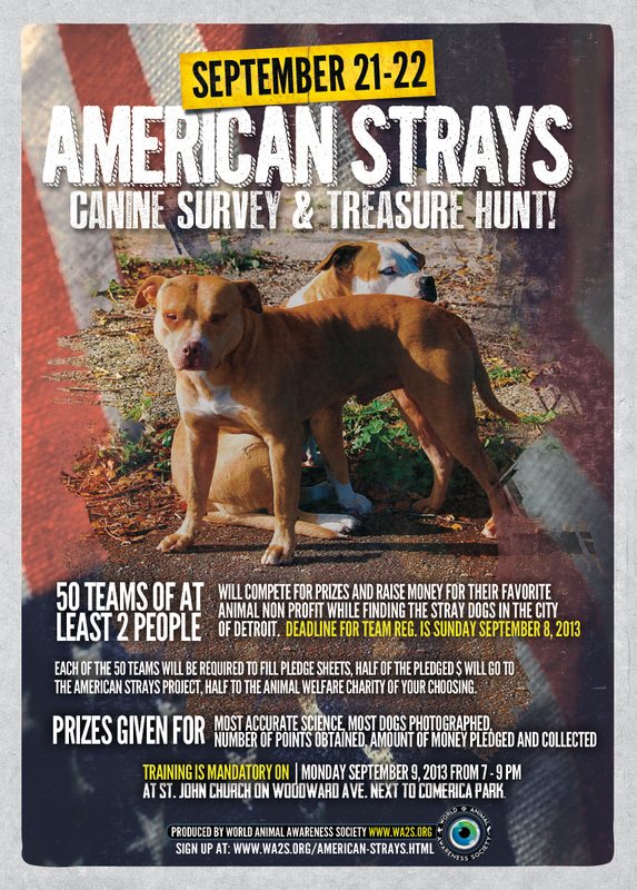
The 1st American Strays Canine Survey & Treasure Hunt took place Saturday & Sunday September 21 & 22, 2013 in the city of Detroit. Look for data to be published in preliminary form in early 1st quarter 2014 and presented at a press event. #AmericanStrays
To be considered for the 2014 surveys across the USA! Sign up here: WA2S VOLUNTEER! AMERICAN STRAYS 2030 Project
|
The 2013 American Strays Canine Survey Poster and some images from the old method of surveying dogs from 2013. See the new 2014 survey methods pdf above.
Description & Scope of Canine Survey Phase 2
|
Canine Survey Sampling Procedures
|
Canine Survey Training Presentation
| ||||||
|
|
During the inaugural American Strays Canine Survey and Treasure Hunt that took place in Detroit, MI over the weekend of September 21 & 22, 2013, volunteer citizen scientists (Observers) used tracking software to track their movements. OSMTracker, a free app for Droid, was used to create this map.
OSMTracker allows the observer to record their tracks and include various media (photos, audio, notes) which is embedded (geo-tagged) into the overall track as way-points. This data is analyzed and used to reconcile the random points the observer looks for within each region as well as have an accurate location for each Dog spotted. |
The following are the primary components of the American Strays ProjectPhase 2 - THE FOUNDATION FOR AN ANNUAL NATIONAL DOG COUNT:
- A complete re-survey of the city of Detroit using Volunteer Citizen Scientists.
- Humanely tagging up to 50 'stray Dogs' in predetermined spaces.
- Creating the Canine survey template to be used for an annual Dog count (similar to Audubon Society Bird Count) in Detroit in 2013 and rest of US in 2015.
- Filming stray Dogs in Detroit for a feature Documentary - The feature differs from the web series, the series follows the people, the feature follows the Dogs.
- Publishing a peer-reviewed scientific paper providing & proving the answer to the question of how many Dogs and the prescribed methods for obtaining the data.
The World Animal Awareness Society science team is using new digital tools during the stray Dog survey portion of this study to measure the "free-roaming" dog population In the fall of 2013. Dozens of teams of volunteers will be led in a two day survey using inexpensive - to free handheld technologies to monitor 1 of 42 regions of Detroit for stray dogs. These volunteers will receive training before the survey day in the smartphone applications that are being used and the data from the smartphone will be received upon the discovery of each dog. Some of the technology being used is shown in the images to the left and below.
OSMTracker: records all locational information of a user directly to one database on a second by second basis. Data collectors and users, to ensure correct census location, will monitor the grid system set in place during the census on OSM maps. OSM will transmit location at all times, and more specifically provide coordinates anytime a user takes a photo, video, or voice recording.
DogDensity Database*: the details of the routes and surveys are recorded in the storage area from the OSMTracker information. This database will store and organize the data and be accessible to future organizations as a template for the census.
DogDensity Database*: the details of the routes and surveys are recorded in the storage area from the OSMTracker information. This database will store and organize the data and be accessible to future organizations as a template for the census.